
I respect Jeff Wise and the thoughtfulness he has brought to the debate over MH370 from the beginning. I do, however, have several issues with his recent piece in NYMag, “How Crazy Am I to Think I Actually Know Where That Malaysia Airlines Plane Is?”
First, the “accessing the electronics hatch” aspect is absurd. When was it accessed? From the point of taxi through about 10,000 feet, a flight attendant would have been sitting in a jumpseat literally on top of this hatch. (This is shown clearly in the video Jeff links to.) Did they access it prior to doors closing? If so, this would have hinged on a flight attendant missing a head count, which is a rather low-percentage shot. Above 10,000 feet? With the seatbelt sign on and flight attendants busily preparing the galley? I find it far-fetched to think that anyone other than a uniformed pilot could have accessed that hatch during the taxi/takeoff/climb/early cruise portions of the flight without causing a level of commotion sufficient to have the pilots informing ATC of a possible problem.
There was no distress call whatsoever. This is, in my mind, the single strongest point discounting anyone outside the flight deck door.
Second, the autoland aspect is equally absurd. A CAT IIIc ILS is a super-precision system, both in the air and on the ground. UAON doesn’t even post a local altimeter setting, meaning a full 50% of the autoland process is ruled out. The nearest navaid is the non-precision NKZ VOR-DME, some 56 nm away. It also stretches the imagination to think that the KGB sent out a team to covertly establish a proper autoland-capable ILS system in order to safely guide an amateur-piloted 777 into a secret hangar and yet somehow choose an airfield with an undulating, asphalt runway in such poor condition it was likely to ruin the whole scheme in the last 14,000 feet. Look at the satellite photo. The surface looks like an abandoned drive-in. Can you imagine having to tell Vladimir Putin his prized Malaysian 777 collapsed its landing gear and is now stuck on a runway in full view of every satellite in space? Neither can your average KGB agent.
Most importantly, an autoland approach involves a long (generally 7 nm) stabilized descent section, much of it in the draggy, fuel-gobbling final landing configuration. This takes fuel. Lots of it.
MH370 simply would not have had the fuel to do it.
In fact, I will attempt to prove below that it would have run out of fuel well shy of UAON and, in the process, cause me to wonder how someone as smart as Jeff Wise could possibly have based such an otherwise well-researched theory on such a flawed foundation.
METHOLODOLGY
Fuel-planning Jeff’s theoretical flight to UAON would be relatively simple had the final ACARS status report coincided with both the last military radar plot at NILAM. This would have established the absolute fuel available for a simple, nearly-direct flight north and it would have clearly defined MH370’s fuel-burn rate in cruise when compared to the 1:07 (17:07Z) ACARS report near TOC (top of climb).
Sadly, this is not the case. What this means is that groundspeed (and, using atmospheric data, true airspeed) is easily computable over the radar-visible portion of the flight, but not over the rest of the flight north to UAON. The trick here is to accurately determine the craft’s groundspeed throughout a highly variable range of winds and air densities.
For the sake of simplicity, I have chosen to separate the flight into three segments:
SEGMENT 1 – Taxi, Takeoff, Climb and Early Cruise through the 01:07 ACARS report showing 96,560 lbs fuel. This portion of the flight took 26 minutes and covered 168nm and is the latest point in the flight where all necessary range data are available.
SEGMENT 2 – Cruise during the portion of the flight known via radar data. This portion of the flight took 1:15, covered 632nm and represents 17.5% of the journey between the 1:07 ACARS report and UAON.
SEGMENT 3 – Jeff Wise’s theoretical flight from waypoint NILAM to UAON, a distance of 3,603nm and representing the remaining 82.5% of the journey.
Segment 1 involves 100% certainty over both groundspeed (GS) and fuel consumption. Segment 2 involves near-100% certainty over GS, reasonable certainty over True Airspeed (TAS), and allows for informed conjecture over fuel consumption. The final segment – the long north-northwesterly leg from the Andaman Sea to Kazakhstan – involves interpolation with respect to virtually every variable.
Given that aircraft range is a function of both Endurance and Groundspeed, I will use the commonly accepted pilot’s practice of first figuring various local True Airspeeds for the entire flight, then factoring Winds Aloft to obtain local groundspeed. I will then average the various groundspeeds over various parts of the flight and factor them against the known fuel flow rates of the 777-200ER to interpret the potential range of MH370, relative to the 3,771 nm total distance Jeff’s theory would require it to cover.
THE ROUTE
The figure below shows Jeff Wise’s proposed flight path to Yubileyniy Airport (ICAO airport code UAON), flying, as Wise surmises, “along borders” to “avoid detection.” Wise accepts the conventional wisdom about that portion of the flight documented by radar, but upon reaching the infamous INMARSAT “arc,” he theorizes a turn to the north, rather than the commonly accepted turn to the south that has resulted in the ongoing search operation of the western shores of Australia:
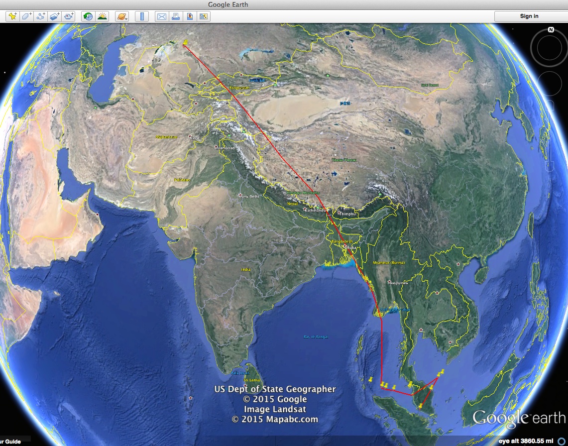
In drawing this flight path, I attempted to emulate the diagram in Wise’s own article, shown below:
The total distance of Jeff’s flight path is 3,771nm, according to Google Earth.
The zigzag portion of MH370’s flight path shown below is derived from a routing accepted by the ATSB (pdf) along route N571 with waypoints VAMPI, MEKAR, NILAM and “possibly IGOGU.”
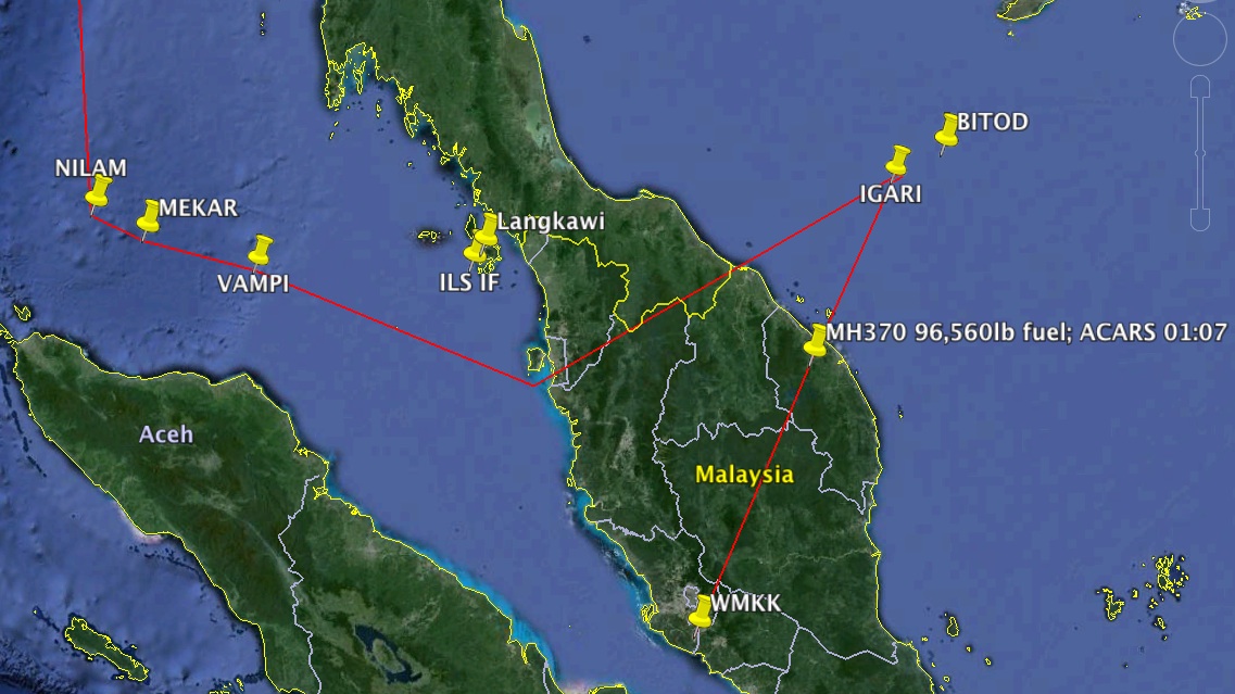
The push-pin labeled “MH370 96,560 lb fuel; ACARS 01:07” represents the end of SEGMENT 1 of the flight. The report (pdf) indicates 43,800kg. I converted.
The push-pin labeled “NILAM” represents the end of SEGMENT 2, the radar data portion of the flight.
The 96,560 lbs of fuel indicated by ACARS at 1:07 local time would have had MH370 landing in Beijing (roughly 2,200nm beyond this fix) with standard fuel reserves.
AIRSPEED
Jeff Wise did a very detailed study of MH370’s probable true airspeeds / ground speeds. Suffice it to say that the true airspeeds discussed range from 481-505 knots, assuming a long-range cruise of Mach 0.84, which is the number upon which Boeing bases its performance advertisements for the 777-200ER.
However, Jeff rightly points out: “As the plane flew along, it burned fuel, and thus became lighter. As a consequence its optimum altitude…became higher, and its LRC [long range cruising speed] at a given altitude would become lower. Additionally, as the plane moved to higher latitudes, the air would have gotten colder, which would reduce its true airspeed for a given Mach number. All these factors would tend to gradually reduce the measured ground speed of the plane, which is indeed what we see geometrically for straight-line flight through the ping rings.”
82.5% of Jeff’s proposed flight operated on a north-northwesterly heading, covering a change of nearly 40 total degrees of latitude. The ground temperature in Malaysia on 3/8/14 was 15 deg C higher than standard (which is 15C/59F), while the ground temperature in Aktjubinsk, Kazakhstan was 30 deg C colder than standard. These historical values can be found here (thanks to Jeff Wise for the link.)
Using a handy atmospheric calculator we can ascertain that at 36,000’ (I will explain why I reference FL360 instead of FL350 below)over Penang, Malaysia – where the temperature aloft was -41.5C – Mach 0.84 translates to 497 knots, while over Aktjubinsk – where the temp at 35,000’ was -58C – Mach 0.84 is only 480 knots.
Taking Jeff’s whole theorized routing and the atmospheric variables into account, it will be necessary to re-figure both TAS and GS for each of the four historical weather reports I was able to obtain with respect to the northbound leg. They are discussed in the next section.
WIND AND GROUNDSPEED
Using Jeff’s own data, we know without a shadow of a doubt that the radar portion of MH370’s flight (exactly 17.5% of Jeff’s theoretical post-1:07 ACARS report flight) took place at an average groundspeed of precisely 475 knots, including the climb to altitude.
However, because we know that the climb/early cruise portion of the flight took 26 minutes and covered 168nm (averaging 388 knots), we must base our computation on 632nm and 1.25 hrs, for a real cruise average groundspeed of 506 kts.
Thus, with 100% certainty, we can establish that Segment 2 (which represents 17.5% of the cruise flight distance) had an average groundspeed of 506 kts.
In order to compute groundspeed for the remaining 82.5% of Jeff’s flight we will interpolate both TAS and GS from the following four historical WX reports spread out among the route, assuming a constant Mach 0.84. I also assumed FL360 (correct for direction of flight / collision avoidance) for the first two reports using weather from March 7th at 1200Z, and a step-climb to FL380 for efficiency for the second two reports, using weather from March 8th at 0000Z.
Yellow push-pins indicate the four WX stations along the route below. Given the spottiness of the historical data available, these were the best fixes I could find in terms of both a proportional spread across the northbound leg as well as lateral proximity to the flightpath:
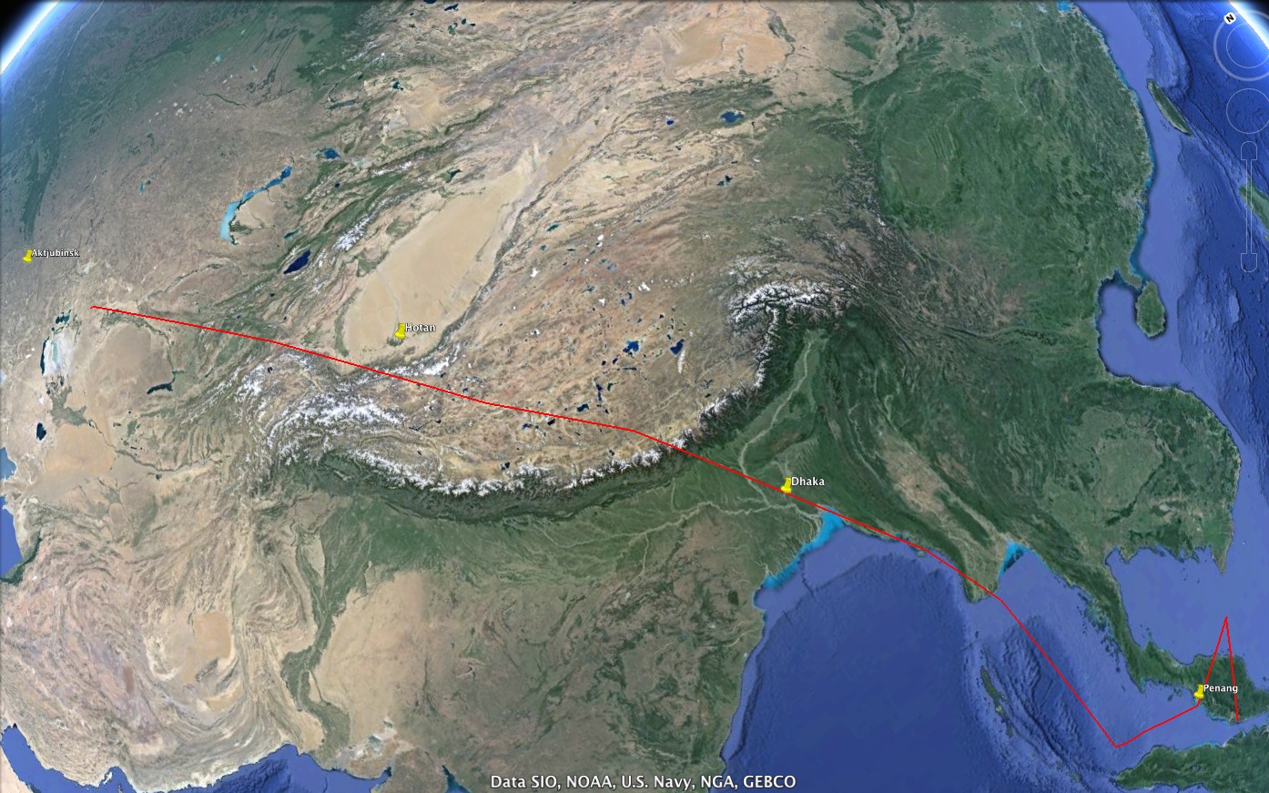
For reference, I calculated wind components using this calculator. Conveniently for me, both Google Earth’s bearing ruler and ICAO winds aloft forecasts operate in True North.
Penang (ICAO code VTSP, WX Mar 07@12Z), local Mach 0.84 was 497 KTAS, True Course 356 degrees. Wind 065@11 which translates to a headwind of 4 kts and a groundspeed of 493 kts.
Dhaka (ICAO code VGTJ, WX Mar 07@12Z), local Mach 0.84 was 496 KTAS, TC 329. Wind 255@134 for a headwind of 37kts and a groundspeed of 459 kts.
Hotan (ICAO code ZWTN, WX Mar 08@00Z), local Mach 0.84 was 477 KTAS, TC 316. Wind 285@49 for a headwind of 42kts and a groundspeed of 435 kts.
Aktjubinsk (ICAO code UATT, WX Mar 08@00Z), local Mach 0.84 was 480 KTAS, TC 305. Wind 000@35 for a headwind of 20kts and a groundspeed of 460 kts.
These figures averaged together result in a groundspeed of 462 knots over the northbound leg of the flight, which is 82.5% of the flight. Averaged against the known average cruise groundspeed of the radar portion of the flight (which is 506 kts over 17.5% of the distance), we know with reasonable certainty, given the data I could find, that the total weighted average groundspeed of MH370, from the 1:07 ACARS report onward, was 470 kts.
462 x 82.5 = 38,115
506 x 17.5 = 8,855
38,115 + 8855 = 46,970 / 100 = 469.70
FUEL BURN
Since we have used various fixes to establish an average groundspeed, we must also work with an average fuel burn to achieve an accurate estimate of range.
Boeing’s own figures (pdf) show that a RR895-equipped -200ER (MH370 was RR892) burns 87,651 lbs of fuel over 3,000 nm carrying 301 passengers.
They use ISA +10C for their cruise altitude figure, so I’ll use that to find the TAS too. M0.84 at 34,300’ (their initial climb figure) is 494 KTAS, for a trip duration of 6.07 hrs. This would seem to indicate an average fuel burn of 14,440 lb/hr.
But not really, of course, because we know from MH370’s 1:07 ACARS report that the first 26 minutes averaged about 390 kts TAS and burned 11,700 lbs for the taxi, takeoff, climb (and six minutes of early cruise since MH370 actually reached FL350 in 20 minutes). MH370 would have been a bit lighter than the quoted Boeing plane, carrying only 227 pax and fueled for only 2,400nm, most likely climbing slightly faster.
If we thus assume a similar 26 minute (0.43 hr), pre-cruise period, burning not 11,700 but slightly more, say a round number of 12,500 lbs of fuel due to the extra weight, and covering the same 168nm. This leaves 75,151 lbs of fuel to cover the remaining 2,832 nm of flying at a groundspeed of 494 kts (Boeing’s “Standard Mission Rules” assume zero wind), a flight of 5.73 hrs. This would indicate an average fuel burn rate in cruise of 13,115 lbs per hour.
I also have anecdotal evidence to back this up. My buddy flies the 777-200ER for United and according to him, the 777 in economy cruise burns “about 6,500 lb/hr per side, plus or minus.” If Jeff Wise or anyone else has a more accurate figure, I’m thrilled to know it. But I’m an instrument-rated pilot with a small amount of jet time and spent a few years designing heavy jets for a popular flight simulator program and I am 100% comfortable with that figure as an average.
So I will use Boeing’s numbers and assume an average fuel burn rate of 13,115 lb/hr.
NOTE: There is an argument to be made that Boeing’s numbers reflect the tankage of reserve fuel (somewhere in the neighborhood of 26,000 lbs) that MH370, by definition, would not have technically been carrying, resulting in higher fuel burn than MH370 would have shown with such empty tanks. If someone had the exact Lift Over Drag Ratio of 9M-MRO in cruise at M 0.84 at FL360 on that exact day, and assuming a cruise SFC of 0.557 from the Trent 892 engine, one could easily apply the Breguet Range Equation to ascertain the precise impact of the extra fuel payload on average burn. I do not have that figure and will therefore proceed with 13,115. When you look at the results below, it will be hard to argue that the extra weight would have made enough difference to materially impact the validity of Jeff’s theory of MH370 reaching Yubileyniy with enough fuel to safely land in a single attempt.
CONCLUSION
MH370’s likely range is thus computed as follows:
Distance from 1:07 ACARS report to UAON: 3,603 nm
Avg groundspeed: 470 kts
Time en route: 7.67 hrs
Fuel burned in 7.67 hrs @ 13,115 lb/hr: 100,592 lbs
Fuel available: 96,560 lbs
FUEL DEFICIT: 4,032 lbs
ENDURANCE DEFICIT: 0.31 hrs
RANGE DEFICIT: 139 nm
MH370 would have flamed out 139 nautical miles from UAON.
Had Jeff Wise delved into a deep discussion of an Air Transat-type deadstick landing after 139 nm of gliding, his overall theory might almost work from an aviation standpoint. But because he gives such emphasis to the airfield, its recent construction, it’s unique “autoland” history and, by implication, the notion that the hijackers were not actual jet pilots and would have needed an autoland capability, I can only conclude that his numbers were either wrong, or he was so wrapped up in the fun of his scenario, he never actually ran the numbers and simply eyeballed the range and called it good.
I furthermore doubt that if the intent of Vladimir Putin (or whoever ordered the operation) was to land the 777 somewhere for some future purpose, his planners would have chosen an airfield at a distance the craft was at least somewhat sure to reach.
I will confess that I have never believed the third-party hijack angle and Jeff’s piece does nothing to change that. The lack of a distress call is the single most compelling aspect of the entire drama. Thus, as I have since the beginning of this tragedy, I still maintain that it was a strange, inexplicable, elaborate murder/suicide by one of the pilots. And as a pilot and obvious aviation-enthusiast myself, it pains me greatly to say that.
I don’t know if it was the Captain or the FO, but it was definitely a guy who wanted to be the perpetrator of a mystery for the ages. If we don’t figure this thing out, I’m afraid he may get his wish.
Respectfully,
Matt Moriarty
Los Angeles, CA
